

Anzorae
Brief overview
- The entire continent of Anzorea is controlled by the monarchy, currently lead by Queen Kezarrae (Razorclawed lineage)
- The northwest coastline is a barren, desert wasteland called “the Sacred Lands” due to the twisted, ruined landscape caused by past battles between powerful gods
- Taxes for cities/towns/villages range from 10% – 25% depending on the level of favor the royal has with the crown
- Adventuring Tax
- Any found magical items must be presented to the court and can be gifted to the royals or be assessed a stiff tariff if the person wants to keep their spoils; sometimes the royals will claim the item for themselves and the “good of the nation” regardless of the presenters wishes.
- 30% of any coins gathered in the act of adventuring shall be paid to the crown
- Individuals who cannot prove ownership of a magical item (provenance documents, bill of sale, etc) or who show signs of gaining unexplained wealth not reported to the court are dealt with harshly
Points of interest in Anzorae
Saleece

- Large, walled city
- Capital of Anzorae
- Home of the royals and Queen Kezarrae
- Nezor Harbor protects the city from the harsh northern seas
- Wardrum Forest –Home to a large tribe of druids who react violently to intruders
- it’s often difficult to tell the druids from the animals
- the wiser citizens of Saleece avoid this forest
- Vargox Mountains – Mined for the wide range of precious metals and gems
- Full of angry monsters and the corpses of would-be adventurers
Hargth

- Primarily a fishing and trade town
- Started off as a small fishing village, but has grown as a popular destination for smugglers and others who want trade outside the eyes of the law and avoid imperial taxes
- Forgery is a popular sport here
- An embarrassing thorn in the royals’ pristine ideals for their nation, especially since it’s so close to the capital
- Queen Kezarrae’s army often runs raids on the town, but have little success due to the many secret doors and hidden tunnels running beneath the Hargth
- Hargth Harbor and the surrounding lands are riddled with underwater passageways, which connect to the land tunnels under Hargth
- It is not common knowledge that within the harbor and water tunnels is the sub-town of Hargthsdowns that is inhabited by merfolk and the like
Sakura

- Lakeside castle
- Fairly autonomous and isolated from the politics of Anzorae
- Being on the edge of the Sacred Lands they get the occasional wave of strange mutated creatures that attack the walled town with mindless rage
- Adventurers that survive the Sacred Lands will often go to Sakura to trade found magical items to avoid the high crown tariffs
- Forgery is a popular sport here as well
- Lake Drom – as long as you stay near the banks, you’ll be fine
Ellim
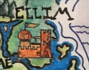
- Medium size city
- At the mouth of the Joramara River
- The land to the north of the Joramara River is lush, fertile farmland
- A lot of small homestead dot the lands north of Ellim and are technically considered under Ellim’s protection
- Known for the inexperienced mages drawn there for the Wizard College
- Home of a wide range of eccentric artisan types
- Moordrae Forest – rangers like it here; no crazy druid tribes
Zomarra

- Keep
- Surrounding land to the North is mostly swamp and the Hargrove River
- Home of the coldly logical schools of thought
- Several monastic and scholarly temples call Zomarra their home
Tansy

- Farming community
- Absolutely no hidden prince or princess wishing for a more exciting life here, just boring laborers.
- Magic users? Bah! No use for that sort here. Go to Ellim if you want to play with the arcane. (Caves in the mountains have several thriving businesses run by clever wizards, sorcerers, witches, warlocks)
Goldspar

- Large coastal town
- Rivals Saleece in population, though more of residents live outside the city walls
- The royals here are secretly plotting to place the crown on their heads
Domaar

- Small village on the largest of the Western Golsmar Islands
General Artist Notes
This was my first try at adding buildings and labels to a map. I can’t draw consistent, level squiggly horizontal water lines, but otherwise I think it’s coming along nicely.
As with the map of Bealdunagaen, I used a combination of pencils, gel pens, crayons, eyeliner, eyeshadow, and a wee bit o blush in the creation of this map.

This work is licensed under a Creative Commons Attribution-NonCommercial-ShareAlike 4.0 International License.

One response to “Map: Anzorae Continent”
[…] The orginally posted version of the Anzorae map with information tidbits on the locations is here. […]
LikeLike